Urban climate Wiesbaden
Wiesbaden has special and typical local landscape structures. The northern part of the city is bordered by the Taunus mountain range with its main ridge running in a north-easterly direction. The urban area extends from the Taunus heights over the Taunus foreland, the Wiesbadener Kessel and the Rheingau down to the Rhine plain, with a difference in altitude of more than 500 meters.
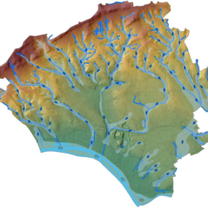
The undeveloped areas and woodland act as fresh and cold air producers. The cold air flowing off the wooded slopes and agricultural land is channelled through the stream valleys into the city center, where it helps to cool down the areas that have been heavily heated by buildings and sealed surfaces on hot days. The river landscapes of the Rhine and Main act as regionally important ventilation channels.
The air currents along the river valleys are important for healthy living conditions in the city. Buildings and sealed surfaces disrupt the ventilation pathways.
History - Climate protection and health care are not a new topic in Wiesbaden
In the 1907 treatise "The climate of Wiesbaden - a climatic study", it is pointed out that Wiesbaden already had 30 years of climate observations in 1899. The climate of the spa town was of particular value early on.
Over the years, the city of Wiesbaden has repeatedly devoted itself to the climate. The first urban climatological survey was carried out between 1994 and 1995. The results were published in Environmental Report No. 9 (1995) and the planning information derived from it was incorporated into the first version of the landscape plan (2002). The first update took place between 2005 and 2011. Its results are presented in Environmental Report No. 22 "Urban Climate Wiesbaden" (2012).
The findings and recommendations for action are reflected in the current expert reports and maps on the urban climate and have been updated.
Current expert reports and maps on the urban climate
The expert report "Stadtklima Wiesbaden" (Wiesbaden Urban Climate) by the Environmental Agency shows various maps on Wiesbaden's urban climate and climate change (update period 2014 - 2021).
The climate function map shows the climatic characteristics of all areas in the entire city area - are they overheated areas or do they serve to supply cold and fresh air?
The climate evaluation map in turn provides planning recommendations for areas with particular significance for the climate - which areas should be particularly protected and kept free from development?
Other maps also provide information on how often particularly hot days and tropical nights will occur in the future due to climate change and how often they are already occurring. The Climate Priority & Affectedness map answers the question of how strongly the Wiesbaden population will be affected.

The results of the "Climate Change in Practice" project run by the Hessian State Agency for Nature Conservation, Environment and Geology, in which the state capitals of Wiesbaden and Mainz took part, were used to create the maps. The "Climate change in practice" project (KLIMPRAX for short) investigated how climate change will affect the cities of Wiesbaden and Mainz. The areas in which measures need to be taken were also identified.
Further information on the KLIMPRAX project can be found here:
Since 2022, the Environment Agency's climate maps have been supplemented by a city-wide climate analysis commissioned by the City Planning Office (INKEK, 2022). The Wiesbaden climate analysis was prepared with the technical support and review of the Environment Agency.
Adaptation to climate change
According to the 2020 progress report of the German Strategy for Adaptation to Climate Change (DAS), urban and spatial planning plays a crucial role in adapting to climate change. This is particularly important in the area of urban climate and air quality, as increasing heat stress has a negative impact on human health. There is therefore a great need for measures to better prepare cities for climate change. Climatic aspects should be taken into account in planning.
DAS is calling for cities to adapt better to climate change, for example to avoid heat stress and extreme weather events. This also includes carrying out urban climate surveys to understand how the climate in a city is changing and what measures need to be taken.
The Spatial Planning Act (ROG) and the Building Code (BauGB) form the legal basis for the necessity of urban climate surveys in the planning process:
- According to Section 1 (5) sentence 2 BauGB, urban land-use plans should, among other things, help to ensure a humane environment and promote climate protection and climate adaptation, especially in urban development.
- In accordance with Section 1 (6) (7) BauGB, the protected goods "air" and "climate", among others, are to be taken into account when drawing up urban land-use plans; accordingly, specialist information is to be implemented in urban climate maps and supplemented by planning information maps derived from them.
One of the tasks of landscape planning is to identify the objectives of nature conservation and landscape management with regard to the protection, improvement and regeneration of air and climate (BNatSchG § 9).