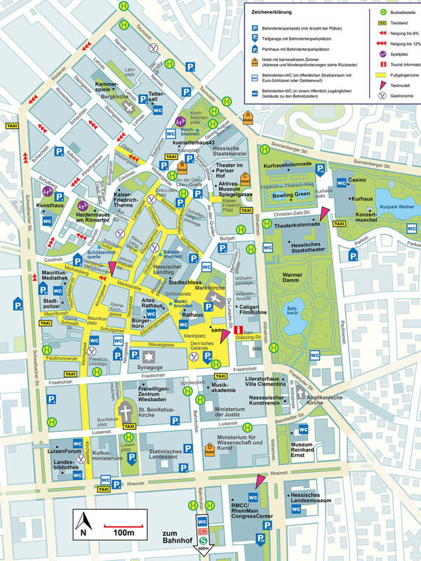
City center map with information on accessibility
The state capital of Wiesbaden presents its new city center map as a printed copy, which also contains a wide range of information on accessibility.
The clearly laid out map offers a comprehensive orientation aid for citizens and visitors and invites them to discover the city center in all its diversity. In addition to information on streets, sights, cultural facilities and tourist destinations, the map contains a wealth of information on accessibility. This includes information on gradients, bus stops, disabled parking spaces, tactile models, accessible restaurants, hotels with accessible rooms and accessible toilets - both in the streets and in public buildings.
The new city center plan is an important step towards an inclusive city in which accessibility is a matter of course. This increases the quality of life and makes it easier to visit the city center. The new city center map is a visible sign of inclusion in practice in Wiesbaden - and a further step on the way to a city that excludes no one.
The city map covers the area of the historic pentagon - bounded by Rheinstraße, Schwalbacher Straße, Röderstraße, Taunusstraße and Wilhelmstraße - and includes central cultural institutions such as the Kurhaus, Casino, Hessisches Staatstheater and the Reinhard Ernst Museum. The offer is supplemented by information on underground car parks, tourist facilities and museums.
The project was initiated and implemented by the city management in close cooperation with the municipal inclusion officer and Wiesbaden Congress & Marketing GmbH. The city's inclusion and accessibility working group was also involved in the development process.
The project is funded by the Federal Ministry of Housing, Urban Development and Building as part of the federal program "Sustainable inner cities and centers" (ZIZ). The aim is to provide new impetus for vibrant city centers with innovative, temporary measures.
Documents
Contact us
Order city map and maps (online)
Address
65189 Wiesbaden
Postal address
65029 Wiesbaden
Arrival
Notes on public transport
Bus stop Statistisches Bundesamt; bus lines 16, 22, 27, 28, 37, 45, X26, x72, 262
Telephone
- +49 611 316317
- +49 611 313980
Information on accessibility
- Barrier-free access is available
- The WC is barrier-free
