In June 2026, the Wiesbaden Fire Department is launching a pilot project in the field of digital operational support: for the first time, a drone that can be automatically alerted will be used in regular operations.
The drone is stationed on the roof of Fire and Rescue Station 3 in Wiesbaden-Igstadt and can be activated at the same time as emergency responders. The goal is to obtain initial aerial images of the incident site shortly after an emergency call is received—often even before the first vehicles arrive. Flight operations are automated and remote-controlled but are monitored at all times by specially trained drone pilots from the company Skyflow. If necessary, they can intervene in the flight immediately.
Especially in cases of wildfires, major incidents, or traffic accidents on the highways around Wiesbaden, the drone provides a quick aerial overview. This allows incident commanders to receive important information early on regarding the spread of the incident, access routes, or potential danger zones, enabling them to prepare measures more effectively.
The transmitted live images are available both at the Wiesbaden Integrated Control Center and directly at the scene of the incident. This allows the situation to be assessed even while en route, enabling tactical planning to be adjusted early on.
The introduction of the system is part of the consistent further development of digital command support at the Wiesbaden Fire Department. Already today, nearly all emergency vehicles are equipped with mobile tablets on which mission-relevant information is provided directly. In addition, the fire department works with networked digital situation maps that allow information, images, and operational data to be exchanged in real time between the control center, incident command, and vehicles. Important property information, such as fire department floor plans or vehicle rescue data sheets, is also available digitally to incident commanders.
Through this project, the Wiesbaden Fire Department is gaining valuable experience for the future use of automated aerial support in civil protection. The results of the trial phase will then be evaluated and incorporated into the further development of the system.
Frequently asked questions
General information
Why does the Wiesbaden fire department use a drone?
In nearly all operations, a quick overview of the scene and the extent of the damage is crucial for a fast and efficient response. The drone helps the fire department gain this overview in the shortest possible time. To do this, the drone is dispatched as soon as emergency personnel are alerted, and it can deliver initial images of the scene even before emergency personnel arrive.
For which operations does the Wiesbaden fire department use the automated drone?
The Wiesbaden Fire Department uses the drone for operations where it can provide a quick overview of the scene or when the scene is located in areas that are difficult to access, such as in the case of fires, floods, traffic accidents, or search-and-rescue operations. It provides important information from the air, which helps improve situational awareness and speed up the response.
What does "automated drone deployment" mean?
“Automated” means that, once cleared by the pilot, the drone flies the calculated route to the mission site on its own. Sensors monitor the flight and detect potential obstacles, which are automatically avoided. The pilot can intervene at any time, for example to avoid crowds or to interrupt the flight if helicopters are approaching. Fully autonomous operation without human supervision does not take place. In addition, numerous areas were defined in advance that may not be flown over for safety reasons.
When and where is the drone used?
The drone is deployed when it is expected to be useful in managing firefighting or disaster response situations. In order to carry out these operations professionally, a limited number of practice and training flights are required. Routine flights or surveillance operations do not take place.
A map showing the drone missions, which are anonymized after the fact, can be accessed via the link below.
The storage, processing, and deletion of data are carried out in accordance with the provisions of the General Data Protection Regulation (GDPR) and the internal data protection guidelines of the City of Wiesbaden. Access is strictly regulated and permitted only to authorized individuals.
Can private properties or persons be captured unintentionally?
The drones take off only when there is a specific firefighting or disaster response operation. General surveillance flights or observations without a specific operational need do not take place.
If it cannot be completely ruled out in the operational area, data is collected only to the extent necessary and is not used to identify individual persons. During the approach, video footage of the surroundings must be transmitted to the drone’s control center so that the safe flight can be monitored. The flight altitude and the focus on the incident site minimize the unintentional collection of personal data.
Legal basis
What is the legal basis for the use of drones?
This operation is conducted within the scope of the fire department’s statutory duties under the Hessian Fire and Disaster Protection Act (HBKG), as well as the aviation regulations of the European Union (EU Drone Regulation) and the German Aviation Regulations.
Who is responsible if a drone causes damage?
The Wiesbaden Fire Department is responsible for the lawful operation of the drones. Skyflow handles the technical aspects of drone operations on behalf of the Wiesbaden Fire Department and ensures that flights are conducted safely. The Wiesbaden Fire Department oversees operations in accordance with legal requirements. All equipment is covered by liability insurance and complies with applicable safety standards.
Technology & Security
How does the automated application work technically?
Drone operations begin automatically based on the location entered into the control center. Flights are monitored at all times by Skyflow pilots.
The drones are equipped with state-of-the-art sensors, thermal imaging cameras, and HD cameras. GPS-enabled systems allow for precise flight paths, automatic return functions, and safe landings.
Can the drone also be used at night and in bad weather?
Drones can generally be operated at night, as GPS positioning works even without line of sight. However, the automated drone will initially be used only during daylight hours. The drone cannot be operated in strong winds, heavy rain, or extreme weather conditions. Drone pilots have constant access to weather data and reports from the aircraft and will abort the mission before the operational limits are reached.
How high does the drone fly?
On the way to and from the scene, the drone flies at an altitude of 100 to 120 meters above ground level. At the scene, the altitude is adjusted to meet local requirements. The minimum altitude is 30 meters to ensure a sufficient distance.
What happens in the event of a technical failure?
The drone is equipped with safety mechanisms such as automatic landing, a return-to-home function, and an emergency shutdown. As an additional safety measure, the drone is fitted with a parachute that significantly reduces the impact energy in the unlikely event of a crash. This minimizes damage caused by a crash of the drones, which are already quite lightweight. Regular maintenance of the drone and ongoing training of personnel ensure safe operation.
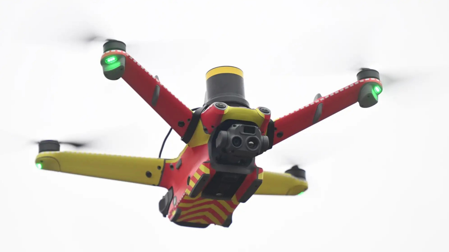
How do you recognize the drone of the Wiesbaden fire department?
The drones used by the Wiesbaden Fire Department are marked with red and yellow decals. However, due to the drone’s small size, this marking is only visible up close and not at normal flight altitudes. As part of airspace monitoring, the drone continuously transmits signals regarding its location, allowing it to be identified by the police, for example.
How is it ensured that the drone does not cause a conflict with private or commercial air traffic?
The fire department’s drone flies at an altitude of 100 to 120 meters. Private and commercial aircraft typically fly much higher when passing over Wiesbaden, so there is no risk of them getting in each other’s way. Fire department drones do not fly in areas where other aircraft take off and land. During drone operations, the incident command coordinates with organizations such as the police or rescue helicopter operators, who also land at locations other than official landing sites.
How loud is the drone?
The drone is very quiet and is barely noticeable amid the urban background noise. It only makes an audible noise when taking off or landing in the immediate vicinity.
Practical application
How does the drone actually support the emergency services?
It provides real-time aerial imagery, thermal imagery, and situational information, which enable more targeted mission planning—for example, to locate the scene of an accident, missing persons, or hot spots.
How often is the drone used?
The drone is deployed only for missions where aerial intelligence is useful. Routine or surveillance flights are not conducted.
Costs & financing
How is the pilot project financed?
The pilot project is funded by the city budget.
Does the use of drones lead to savings?
In the long term, this technology contributes to more efficient emergency response, as operations can be carried out in a more targeted, safer, and faster manner. The savings may result, for example, from reduced damage or fewer emergency calls and thus lower fuel consumption, but are difficult to quantify. However, an increase in public safety can be expected with relatively little financial investment.